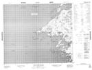
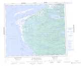
Maps showing Pointe Shave, Baie-James; Jamésie, Quebec
Pointe Shave is a Cape located in Baie-James; Jamésie, Quebec.
- Latitude: 54° 36' 47'' North (decimal: 54.6130556)
- Longitude: 79° 39' 31'' West (decimal: -79.6586111)
- Topography Feature Category: Cape
- Geographical Feature: Pointe
- Canadian Province/Territory: Quebec
- Location: Baie-James; Jamésie
- Atlas of Canada Locator Map: Pointe Shave
- GPS Coordinate Locator Map: Pointe Shave Lat/Long
Pointe Shave NTS Map Sheets