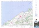
Maps showing Mont-Joli, Mont-Joli; La Mitis, Quebec
Mont-Joli is a City located in Mont-Joli; La Mitis, Quebec and has an elevation of 100 meters.
- Latitude: 48° 35' North (decimal: 48.5833333)
- Longitude: 68° 11' West (decimal: -68.1833333)
- Topography Feature Category: City
- Geographical Feature: Ville
- Canadian Province/Territory: Quebec
- Elevation: 100 meters
- Location: Mont-Joli; La Mitis
- Atlas of Canada Locator Map: Mont-Joli
- GPS Coordinate Locator Map: Mont-Joli Lat/Long