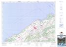
Maps showing Rivière Sainte-Anne, Rimouski; Rimouski-Neigette, Quebec
Rivière Sainte-Anne is a River located in Rimouski; Rimouski-Neigette, Quebec and has an elevation of 1 meters.
- Latitude: 48° 30' 49'' North (decimal: 48.5136494)
- Longitude: 68° 27' 52'' West (decimal: -68.4644652)
- Topography Feature Category: River
- Geographical Feature: Rivière
- Canadian Province/Territory: Quebec
- Elevation: 1 meters
- Location: Rimouski; Rimouski-Neigette
- Atlas of Canada Locator Map: Rivière Sainte-Anne
- GPS Coordinate Locator Map: Rivière Sainte-Anne Lat/Long