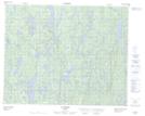
Maps showing Kaku Hipu Kakustshenan, Petit-Mécatina; Minganie, Quebec
Kaku Hipu Kakustshenan is a Unincorporated area located in Petit-Mécatina; Minganie, Quebec.
- Latitude: 51° 34' 48'' North (decimal: 51.5800568)
- Longitude: 58° 21' 55'' West (decimal: -58.3651977)
- Topography Feature Category: Unincorporated area
- Geographical Feature: Lieu-dit
- Canadian Province/Territory: Quebec
- Location: Petit-Mécatina; Minganie
- Atlas of Canada Locator Map: Kaku Hipu Kakustshenan
- GPS Coordinate Locator Map: Kaku Hipu Kakustshenan Lat/Long
Kaku Hipu Kakustshenan NTS Map Sheets