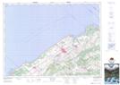
Maps showing Cours d'eau Langlois, Sainte-Angèle-de-Mérici; La Mitis, Quebec
Cours d'eau Langlois is a River located in Sainte-Angèle-de-Mérici; La Mitis, Quebec.
- Latitude: 48° 32' 57'' North (decimal: 48.5492074)
- Longitude: 68° 8' 27'' West (decimal: -68.1408488)
- Topography Feature Category: River
- Geographical Feature: Cours d'eau agricole
- Canadian Province/Territory: Quebec
- Location: Sainte-Angèle-de-Mérici; La Mitis
- Atlas of Canada Locator Map: Cours d'eau Langlois
- GPS Coordinate Locator Map: Cours d'eau Langlois Lat/Long