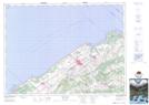
Maps showing Luceville, Sainte-Luce; La Mitis, Quebec
Luceville is a Unincorporated area located in Sainte-Luce; La Mitis, Quebec.
- Latitude: 48° 31' 40'' North (decimal: 48.5278172)
- Longitude: 68° 20' 43'' West (decimal: -68.3452967)
- Topography Feature Category: Unincorporated area
- Geographical Feature: Secteur
- Canadian Province/Territory: Quebec
- Location: Sainte-Luce; La Mitis
- Atlas of Canada Locator Map: Luceville
- GPS Coordinate Locator Map: Luceville Lat/Long