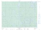
Maps showing Matachewan Indian Reserve 72, Timiskaming, Ontario
Matachewan Indian Reserve 72 is a Indian Reserve located in Timiskaming, Ontario.
- Latitude: 48° 5' North (decimal: 48.0832999)
- Longitude: 80° 38' West (decimal: -80.6333000)
- Topography Feature Category: Indian Reserve
- Geographical Feature: Indian Reserve
- Canadian Province/Territory: Ontario
- Location: Timiskaming
- Atlas of Canada Locator Map: Matachewan Indian Reserve 72
- GPS Coordinate Locator Map: Matachewan Indian Reserve 72 Lat/Long
Matachewan Indian Reserve 72 NTS Map Sheets