Canada Topographic Maps

Amewin River Topo Maps

Topography maps and Latitude/Longitude Location

Maps showing Amewin River, Cochrane, Ontario

Amewin River is a River located in Cochrane, Ontario.

  • Latitude: 52° 6' 47'' North   (decimal: 52.1130555)
  • Longitude: 81° 22' 50'' West   (decimal: -81.3805555)
  • Topography Feature Category: River
  • Geographical Feature: River
  • Canadian Province/Territory: Ontario
  • Location: Cochrane
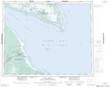
  • Atlas of Canada Locator Map: Amewin River
  • GPS Coordinate Locator Map: Amewin River Lat/Long

Amewin River NTS Map Sheets

042P13 No Title Topographic Map at 1:50,000 scale

042P14 Luchan River Topographic Map at 1:50,000 scale

043A03 Nomansland Point Topographic Map at 1:50,000 scale

042P Moosonee Topographic Map at 1:250,000 scale

043A Fort Albany Topographic Map at 1:250,000 scale

 
Buy Topographic Maps DVD
Newsletter Sign-up

Yes, I want to receive map store discounts.


Bookmark and Share