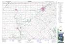
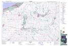
Maps showing Brown Creek, Lambton, Ontario
Brown Creek is a River located in Lambton, Ontario and has an elevation of 244 meters.
- Latitude: 42° 51' 58'' North (decimal: 42.8661111)
- Longitude: 81° 52' 13'' West (decimal: -81.8702777)
- Topography Feature Category: River
- Geographical Feature: Creek
- Canadian Province/Territory: Ontario
- Elevation: 244 meters
- Location: Lambton
- Atlas of Canada Locator Map: Brown Creek
- GPS Coordinate Locator Map: Brown Creek Lat/Long
Brown Creek NTS Map Sheets