Maps showing Goulais River, Algoma, Ontario
Goulais River is a River located in Algoma, Ontario and has an elevation of 254 meters.
- Latitude: 46° 42' 40'' North (decimal: 46.7111111)
- Longitude: 84° 26' 47'' West (decimal: -84.4463888)
- Topography Feature Category: River
- Geographical Feature: River
- Canadian Province/Territory: Ontario
- Elevation: 254 meters
- Location: Algoma
- Atlas of Canada Locator Map: Goulais River
- GPS Coordinate Locator Map: Goulais River Lat/Long
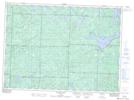
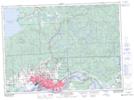
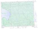
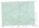
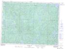
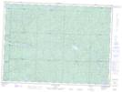
Goulais River NTS Map Sheets
041J13 Ranger Lake Topographic Map at 1:50,000 scale
041K09 Sault Ste Marie Topographic Map at 1:50,000 scale
041K16 Searchmont Topographic Map at 1:50,000 scale
041N01 Batchewana Topographic Map at 1:50,000 scale
041O04 Welcome Lake Topographic Map at 1:50,000 scale
041O05 Bulley Lake Topographic Map at 1:50,000 scale
041J Blind River Topographic Map at 1:250,000 scale
041K Sault Ste Marie Topographic Map at 1:250,000 scale
041N Michipicoten Topographic Map at 1:250,000 scale
041O Chapleau Topographic Map at 1:250,000 scale