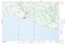
Maps showing Griffin Corners, Ontario
Griffin Corners is a Unincorporated area located in Ontario.
- Latitude: 42° 42' 37'' North (decimal: 42.7103000)
- Longitude: 80° 47' 2'' West (decimal: -80.7838999)
- Topography Feature Category: Unincorporated area
- Geographical Feature: Dispersed Rural Community
- Canadian Province/Territory: Ontario
- GPS Coordinate Locator Map: Griffin Corners Lat/Long