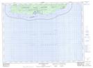
Maps showing The Hummock, Thunder Bay, Ontario
The Hummock is a Shoal located in Thunder Bay, Ontario.
- Latitude: 47° 34' 48'' North (decimal: 47.5800000)
- Longitude: 85° 49' 40'' West (decimal: -85.8277777)
- Topography Feature Category: Shoal
- Geographical Feature: Hummock
- Canadian Province/Territory: Ontario
- Location: Thunder Bay
- Atlas of Canada Locator Map: The Hummock
- GPS Coordinate Locator Map: The Hummock Lat/Long
The Hummock NTS Map Sheets