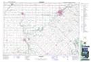
Maps showing Inwood, Lambton, Ontario
Inwood is a Unincorporated area located in Lambton, Ontario and has an elevation of 207 meters.
- Latitude: 42° 49' North (decimal: 42.8166666)
- Longitude: 81° 59' West (decimal: -81.9833333)
- Topography Feature Category: Unincorporated area
- Geographical Feature: Locality
- Canadian Province/Territory: Ontario
- Elevation: 207 meters
- Location: Lambton
- Atlas of Canada Locator Map: Inwood
- GPS Coordinate Locator Map: Inwood Lat/Long