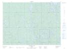
Maps showing Redpine Narrows, Timiskaming, Ontario
Redpine Narrows is a Channel located in Timiskaming, Ontario and has an elevation of 307 meters.
- Latitude: 48° 3' 40'' North (decimal: 48.0611111)
- Longitude: 80° 43' 33'' West (decimal: -80.7258333)
- Topography Feature Category: Channel
- Geographical Feature: Narrows
- Canadian Province/Territory: Ontario
- Elevation: 307 meters
- Location: Timiskaming
- Atlas of Canada Locator Map: Redpine Narrows
- GPS Coordinate Locator Map: Redpine Narrows Lat/Long
Redpine Narrows NTS Map Sheets