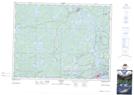
Maps showing Sieler's Island, Kenora, Ontario
Sieler's Island is a Island located in Kenora, Ontario and has an elevation of 334 meters.
- Latitude: 49° 56' 4'' North (decimal: 49.9344444)
- Longitude: 94° 35' 25'' West (decimal: -94.5902777)
- Topography Feature Category: Island
- Geographical Feature: Island
- Canadian Province/Territory: Ontario
- Elevation: 334 meters
- Location: Kenora
- Atlas of Canada Locator Map: Sieler's Island
- GPS Coordinate Locator Map: Sieler's Island Lat/Long