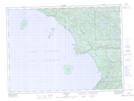
Maps showing Sinclair Cove, Algoma, Ontario
Sinclair Cove is a Bay located in Algoma, Ontario and has an elevation of 196 meters.
- Latitude: 47° 22' 31'' North (decimal: 47.3752777)
- Longitude: 84° 42' 14'' West (decimal: -84.7038888)
- Topography Feature Category: Bay
- Geographical Feature: Cove
- Canadian Province/Territory: Ontario
- Elevation: 196 meters
- Location: Algoma
- Atlas of Canada Locator Map: Sinclair Cove
- GPS Coordinate Locator Map: Sinclair Cove Lat/Long
Sinclair Cove NTS Map Sheets