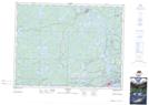
Maps showing Paddy Creek, Kenora, Ontario
Paddy Creek is a River located in Kenora, Ontario and has an elevation of 334 meters.
- Latitude: 49° 55' 28'' North (decimal: 49.9244444)
- Longitude: 94° 42' 10'' West (decimal: -94.7027777)
- Topography Feature Category: River
- Geographical Feature: Creek
- Canadian Province/Territory: Ontario
- Elevation: 334 meters
- Location: Kenora
- Atlas of Canada Locator Map: Paddy Creek
- GPS Coordinate Locator Map: Paddy Creek Lat/Long