Maps showing Minnie Reef, Algoma, Ontario
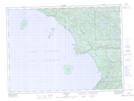
Minnie Reef is a Shoal located in Algoma, Ontario.
- Latitude: 47° 24' 23'' North (decimal: 47.4063888)
- Longitude: 84° 50' 42'' West (decimal: -84.8449999)
- Topography Feature Category: Shoal
- Geographical Feature: Reef
- Canadian Province/Territory: Ontario
- Location: Algoma
- Atlas of Canada Locator Map: Minnie Reef
- GPS Coordinate Locator Map: Minnie Reef Lat/Long
Minnie Reef NTS Map Sheets