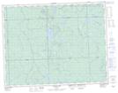
Maps showing Arnott, Algoma, Ontario
Arnott is a Geographical area located in Algoma, Ontario.
- Latitude: 49° 38' 35'' North (decimal: 49.6430555)
- Longitude: 84° 34' 51'' West (decimal: -84.5808333)
- Topography Feature Category: Geographical area
- Geographical Feature: Geographic Township
- Canadian Province/Territory: Ontario
- Location: Algoma
- Atlas of Canada Locator Map: Arnott
- GPS Coordinate Locator Map: Arnott Lat/Long
Arnott NTS Map Sheets