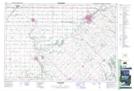
Maps showing Chippewas of the Thames First Nation Indian Reserve 42, Middlesex, Ontario
Chippewas of the Thames First Nation Indian Reserve 42 is a Indian Reserve located in Middlesex, Ontario.
- Latitude: 42° 49' 0'' North (decimal: 42.8167000)
- Longitude: 81° 29' 30'' West (decimal: -81.4916999)
- Topography Feature Category: Indian Reserve
- Geographical Feature: Indian Reserve
- Canadian Province/Territory: Ontario
- Location: Middlesex
- Atlas of Canada Locator Map: Chippewas of the Thames First Nation Indian Reserve 42
- GPS Coordinate Locator Map: Chippewas of the Thames First Nation Indian Reserve 42 Lat/Long
Chippewas of the Thames First Nation Indian Reserve 42 NTS Map Sheets