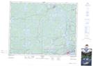
Maps showing Graham Island, Pelican, Ontario
Graham Island is a Island located in Pelican, Ontario.
- Latitude: 49° 50' 58'' North (decimal: 49.8495619)
- Longitude: 94° 51' 2'' West (decimal: -94.8506430)
- Topography Feature Category: Island
- Geographical Feature: Island
- Canadian Province/Territory: Ontario
- Location: Pelican
- Atlas of Canada Locator Map: Graham Island
- GPS Coordinate Locator Map: Graham Island Lat/Long