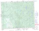
Maps showing Amoskawaywi Rapids, Manitoba
Amoskawaywi Rapids is a Rapids located in Manitoba.
- Latitude: 51° 44' 19'' North (decimal: 51.7386000)
- Longitude: 96° 17' 13'' West (decimal: -96.2869000)
- Topography Feature Category: Rapids
- Geographical Feature: Rapids
- Canadian Province/Territory: Manitoba
- GPS Coordinate Locator Map: Amoskawaywi Rapids Lat/Long