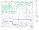
Maps showing Baie St. Paul Bridge, Manitoba
Baie St. Paul Bridge is a Road feature located in Manitoba and has an elevation of 244 meters.
- Latitude: 50° 0' 43'' North (decimal: 50.0119000)
- Longitude: 97° 45' 34'' West (decimal: -97.7594000)
- Topography Feature Category: Road feature
- Geographical Feature: Bridge
- Canadian Province/Territory: Manitoba
- Elevation: 244 meters
- Atlas of Canada Locator Map: Baie St. Paul Bridge
- GPS Coordinate Locator Map: Baie St. Paul Bridge Lat/Long