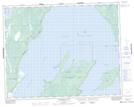
Maps showing Beaver Creek Provincial Recreation Park, Manitoba
Beaver Creek Provincial Recreation Park is a Conservation area located in Manitoba and has an elevation of 219 meters.
- Latitude: 51° 22' 35'' North (decimal: 51.3763999)
- Longitude: 96° 54' 56'' West (decimal: -96.9156000)
- Topography Feature Category: Conservation area
- Geographical Feature: Provincial Recreation Park
- Canadian Province/Territory: Manitoba
- Elevation: 219 meters
- Atlas of Canada Locator Map: Beaver Creek Provincial Recreation Park
- GPS Coordinate Locator Map: Beaver Creek Provincial Recreation Park Lat/Long
Beaver Creek Provincial Recreation Park NTS Map Sheets