Canada Topographic Maps

Chief Lake Topo Maps

Topography maps and Latitude/Longitude Location

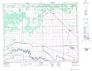
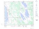
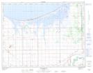
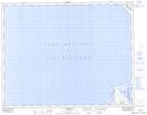
Maps showing Chief Lake, 15-4-W, Manitoba

Chief Lake is a Lake located in 15-4-W, Manitoba and has an elevation of 247 meters.

  • Latitude: 50° 14' 52'' North   (decimal: 50.2478000)
  • Longitude: 98° 0' 1'' West   (decimal: -98.0003000)
  • Topography Feature Category: Lake
  • Geographical Feature: Lake
  • Canadian Province/Territory: Manitoba
  • Elevation: 247 meters
  • Location: 15-4-W
  • Atlas of Canada Locator Map: Chief Lake
  • GPS Coordinate Locator Map: Chief Lake Lat/Long

Chief Lake NTS Map Sheets

062I04 Warren Topographic Map at 1:50,000 scale

062I05 St Laurent Topographic Map at 1:50,000 scale

062J01 Macdonald Topographic Map at 1:50,000 scale

062J08 St Ambroise Topographic Map at 1:50,000 scale

062I Selkirk Topographic Map at 1:250,000 scale

062J Neepawa Topographic Map at 1:250,000 scale

 
Buy Topographic Maps DVD
Newsletter Sign-up

Yes, I want to receive map store discounts.


Bookmark and Share