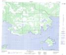
Maps showing Deer Point, 47-22-W, Manitoba
Deer Point is a Cape located in 47-22-W, Manitoba.
- Latitude: 53° 2' 25'' North (decimal: 53.0402999)
- Longitude: 100° 31' 58'' West (decimal: -100.5328000)
- Topography Feature Category: Cape
- Geographical Feature: Point
- Canadian Province/Territory: Manitoba
- Location: 47-22-W
- Atlas of Canada Locator Map: Deer Point
- GPS Coordinate Locator Map: Deer Point Lat/Long
Deer Point NTS Map Sheets