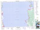
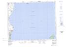
Maps showing Elk Island Provincial Heritage Park, Manitoba
Elk Island Provincial Heritage Park is a Conservation area located in Manitoba and has an elevation of 221 meters.
- Latitude: 50° 45' 17'' North (decimal: 50.7547000)
- Longitude: 96° 32' 45'' West (decimal: -96.5458000)
- Topography Feature Category: Conservation area
- Geographical Feature: Provincial Heritage Park
- Canadian Province/Territory: Manitoba
- Elevation: 221 meters
- Atlas of Canada Locator Map: Elk Island Provincial Heritage Park
- GPS Coordinate Locator Map: Elk Island Provincial Heritage Park Lat/Long
Elk Island Provincial Heritage Park NTS Map Sheets