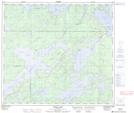
Maps showing Figure Lake, 88,89-12-W, Manitoba
Figure Lake is a Lake located in 88,89-12-W, Manitoba and has an elevation of 302 meters.
- Latitude: 56° 40' 45'' North (decimal: 56.6792000)
- Longitude: 99° 13' 25'' West (decimal: -99.2235999)
- Topography Feature Category: Lake
- Geographical Feature: Lake
- Canadian Province/Territory: Manitoba
- Elevation: 302 meters
- Location: 88,89-12-W
- Atlas of Canada Locator Map: Figure Lake
- GPS Coordinate Locator Map: Figure Lake Lat/Long
Figure Lake NTS Map Sheets