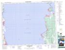
Maps showing Grand Marais Point, 24-18-6-E, Manitoba
Grand Marais Point is a Cape located in 24-18-6-E, Manitoba and has an elevation of 216 meters.
- Latitude: 50° 33' 40'' North (decimal: 50.5610999)
- Longitude: 96° 38' 00'' West (decimal: -96.6333000)
- Topography Feature Category: Cape
- Geographical Feature: Point
- Canadian Province/Territory: Manitoba
- Elevation: 216 meters
- Location: 24-18-6-E
- Atlas of Canada Locator Map: Grand Marais Point
- GPS Coordinate Locator Map: Grand Marais Point Lat/Long
Grand Marais Point NTS Map Sheets