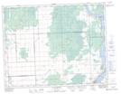
Maps showing Great Falls Generating Station, 27-17-11-E, Manitoba
Great Falls Generating Station is a Hydraulic construction located in 27-17-11-E, Manitoba.
- Latitude: 50° 27' 43'' North (decimal: 50.4619000)
- Longitude: 96° 0' 35'' West (decimal: -96.0097000)
- Topography Feature Category: Hydraulic construction
- Geographical Feature: Generating Station
- Canadian Province/Territory: Manitoba
- Location: 27-17-11-E
- Atlas of Canada Locator Map: Great Falls Generating Station
- GPS Coordinate Locator Map: Great Falls Generating Station Lat/Long
Great Falls Generating Station NTS Map Sheets