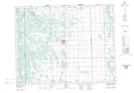
Maps showing Gunton, 33-15-2-E, Manitoba
Gunton is a Unincorporated area located in 33-15-2-E, Manitoba and has an elevation of 249 meters.
- Latitude: 50° 19' 5'' North (decimal: 50.3181000)
- Longitude: 97° 15' 58'' West (decimal: -97.2661000)
- Topography Feature Category: Unincorporated area
- Geographical Feature: Community
- Canadian Province/Territory: Manitoba
- Elevation: 249 meters
- Location: 33-15-2-E
- Atlas of Canada Locator Map: Gunton
- GPS Coordinate Locator Map: Gunton Lat/Long