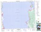
Maps showing Ironwood Point, 30-19-7-E, Manitoba
Ironwood Point is a Cape located in 30-19-7-E, Manitoba and has an elevation of 218 meters.
- Latitude: 50° 39' 43'' North (decimal: 50.6619000)
- Longitude: 96° 36' 10'' West (decimal: -96.6028000)
- Topography Feature Category: Cape
- Geographical Feature: Point
- Canadian Province/Territory: Manitoba
- Elevation: 218 meters
- Location: 30-19-7-E
- Atlas of Canada Locator Map: Ironwood Point
- GPS Coordinate Locator Map: Ironwood Point Lat/Long
Ironwood Point NTS Map Sheets