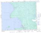
Maps showing Kaneeshotekwayak Creek, 32-6-E, Manitoba
Kaneeshotekwayak Creek is a River located in 32-6-E, Manitoba and has an elevation of 219 meters.
- Latitude: 51° 45' 37'' North (decimal: 51.7603000)
- Longitude: 96° 41' 17'' West (decimal: -96.6880999)
- Topography Feature Category: River
- Geographical Feature: Creek
- Canadian Province/Territory: Manitoba
- Elevation: 219 meters
- Location: 32-6-E
- Atlas of Canada Locator Map: Kaneeshotekwayak Creek
- GPS Coordinate Locator Map: Kaneeshotekwayak Creek Lat/Long
Kaneeshotekwayak Creek NTS Map Sheets