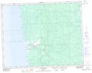
Maps showing Kapukwaywetewunk Creek, 27-21-9-E, Manitoba
Kapukwaywetewunk Creek is a River located in 27-21-9-E, Manitoba and has an elevation of 236 meters.
- Latitude: 50° 48' 33'' North (decimal: 50.8091999)
- Longitude: 96° 16' 55'' West (decimal: -96.2819000)
- Topography Feature Category: River
- Geographical Feature: Creek
- Canadian Province/Territory: Manitoba
- Elevation: 236 meters
- Location: 27-21-9-E
- Atlas of Canada Locator Map: Kapukwaywetewunk Creek
- GPS Coordinate Locator Map: Kapukwaywetewunk Creek Lat/Long
Kapukwaywetewunk Creek NTS Map Sheets