Canada Topographic Maps

Mill Creek Topo Maps

Topography maps and Latitude/Longitude Location

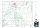
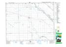
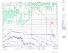
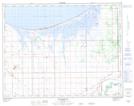
Maps showing Mill Creek, Manitoba

Mill Creek is a River located in Manitoba and has an elevation of 244 meters.

  • Latitude: 49° 58' 53'' North   (decimal: 49.9813999)
  • Longitude: 97° 41' 14'' West   (decimal: -97.6872000)
  • Topography Feature Category: River
  • Geographical Feature: Creek
  • Canadian Province/Territory: Manitoba
  • Elevation: 244 meters
  • Atlas of Canada Locator Map: Mill Creek
  • GPS Coordinate Locator Map: Mill Creek Lat/Long

Mill Creek NTS Map Sheets

062G16 Portage La Prairie Topographic Map at 1:50,000 scale

062H13 Elie Topographic Map at 1:50,000 scale

062I04 Warren Topographic Map at 1:50,000 scale

062J01 Macdonald Topographic Map at 1:50,000 scale

062G Brandon Topographic Map at 1:250,000 scale

062H Winnipeg Topographic Map at 1:250,000 scale

062I Selkirk Topographic Map at 1:250,000 scale

062J Neepawa Topographic Map at 1:250,000 scale

 
Buy Topographic Maps DVD
Newsletter Sign-up

Yes, I want to receive map store discounts.


Bookmark and Share