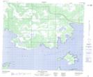
Maps showing North Shore Creek, 9-48-24-W, Manitoba
North Shore Creek is a River located in 9-48-24-W, Manitoba.
- Latitude: 53° 7' 30'' North (decimal: 53.1250000)
- Longitude: 100° 54' 25'' West (decimal: -100.9068999)
- Topography Feature Category: River
- Geographical Feature: Creek
- Canadian Province/Territory: Manitoba
- Location: 9-48-24-W
- Atlas of Canada Locator Map: North Shore Creek
- GPS Coordinate Locator Map: North Shore Creek Lat/Long
North Shore Creek NTS Map Sheets