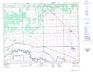
Maps showing Poplar Point, Manitoba
Poplar Point is a Unincorporated area located in Manitoba and has an elevation of 244 meters.
- Latitude: 50° 3' 25'' North (decimal: 50.0568999)
- Longitude: 97° 58' 36'' West (decimal: -97.9766999)
- Topography Feature Category: Unincorporated area
- Geographical Feature: Community
- Canadian Province/Territory: Manitoba
- Elevation: 244 meters
- Atlas of Canada Locator Map: Poplar Point
- GPS Coordinate Locator Map: Poplar Point Lat/Long