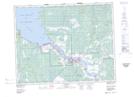
Maps showing Powerview, 18-10-E, Manitoba
Powerview is a Village located in 18-10-E, Manitoba and has an elevation of 224 meters.
- Latitude: 50° 33' 58'' North (decimal: 50.5661108)
- Longitude: 96° 11' 53'' West (decimal: -96.198056)
- Topography Feature Category: Village
- Geographical Feature: Village
- Canadian Province/Territory: Manitoba
- Elevation: 224 meters
- Location: 18-10-E
- Atlas of Canada Locator Map: Powerview
- GPS Coordinate Locator Map: Powerview Lat/Long