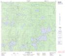
Maps showing Wapawsik, 32-81-8-W, Manitoba
Wapawsik is a Unincorporated area located in 32-81-8-W, Manitoba and has an elevation of 264 meters.
- Latitude: 56° 3' 27'' North (decimal: 56.0574999)
- Longitude: 98° 40' 54'' West (decimal: -98.6816999)
- Topography Feature Category: Unincorporated area
- Geographical Feature: Locality
- Canadian Province/Territory: Manitoba
- Elevation: 264 meters
- Location: 32-81-8-W
- Atlas of Canada Locator Map: Wapawsik
- GPS Coordinate Locator Map: Wapawsik Lat/Long
Wapawsik NTS Map Sheets