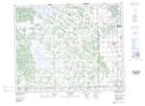
Maps showing Tern Pond, NW20-20-4-E, Manitoba
Tern Pond is a Lake located in NW20-20-4-E, Manitoba.
- Latitude: 50° 44' 10'' North (decimal: 50.7361000)
- Longitude: 97° 1' 1'' West (decimal: -97.0169000)
- Topography Feature Category: Lake
- Geographical Feature: Pond
- Canadian Province/Territory: Manitoba
- Location: NW20-20-4-E
- Atlas of Canada Locator Map: Tern Pond
- GPS Coordinate Locator Map: Tern Pond Lat/Long