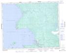
Maps showing Long Body Creek, 23,26-32-6-E, Manitoba
Long Body Creek is a Unincorporated area located in 23,26-32-6-E, Manitoba.
- Latitude: 51° 45' 58'' North (decimal: 51.7660999)
- Longitude: 96° 38' 49'' West (decimal: -96.6469000)
- Topography Feature Category: Unincorporated area
- Geographical Feature: Northern Community
- Canadian Province/Territory: Manitoba
- Location: 23,26-32-6-E
- Atlas of Canada Locator Map: Long Body Creek
- GPS Coordinate Locator Map: Long Body Creek Lat/Long
Long Body Creek NTS Map Sheets