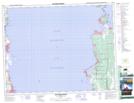
Maps showing Lake Forest, 21 - 20 - 4E, Manitoba
Lake Forest is a Unincorporated area located in 21 - 20 - 4E, Manitoba.
- Latitude: 50° 44' 22'' North (decimal: 50.7393999)
- Longitude: 96° 59' 22'' West (decimal: -96.9893999)
- Topography Feature Category: Unincorporated area
- Geographical Feature: Community
- Canadian Province/Territory: Manitoba
- Location: 21 - 20 - 4E
- Atlas of Canada Locator Map: Lake Forest
- GPS Coordinate Locator Map: Lake Forest Lat/Long
Lake Forest NTS Map Sheets