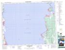
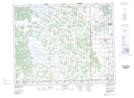
Maps showing Shorepointe Village, 20 - 19 - 4E, Manitoba
Shorepointe Village is a Unincorporated area located in 20 - 19 - 4E, Manitoba.
- Latitude: 50° 38' 30'' North (decimal: 50.6417000)
- Longitude: 96° 59' 52'' West (decimal: -96.9978000)
- Topography Feature Category: Unincorporated area
- Geographical Feature: Community
- Canadian Province/Territory: Manitoba
- Location: 20 - 19 - 4E
- Atlas of Canada Locator Map: Shorepointe Village
- GPS Coordinate Locator Map: Shorepointe Village Lat/Long
Shorepointe Village NTS Map Sheets