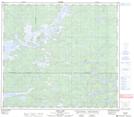
Maps showing Watters Island, 85-13W, Manitoba
Watters Island is a Island located in 85-13W, Manitoba.
- Latitude: 56° 25' 0'' North (decimal: 56.4167000)
- Longitude: 99° 22' 28'' West (decimal: -99.3744000)
- Topography Feature Category: Island
- Geographical Feature: Island
- Canadian Province/Territory: Manitoba
- Location: 85-13W
- Atlas of Canada Locator Map: Watters Island
- GPS Coordinate Locator Map: Watters Island Lat/Long
Watters Island NTS Map Sheets