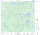
Maps showing Campbell Falls, 84-5W, Manitoba
Campbell Falls is a Falls located in 84-5W, Manitoba.
- Latitude: 56° 15' 58'' North (decimal: 56.2660999)
- Longitude: 98° 12' 32'' West (decimal: -98.2089000)
- Topography Feature Category: Falls
- Geographical Feature: Falls
- Canadian Province/Territory: Manitoba
- Location: 84-5W
- Atlas of Canada Locator Map: Campbell Falls
- GPS Coordinate Locator Map: Campbell Falls Lat/Long
Campbell Falls NTS Map Sheets