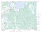
Maps showing Fisher River Cree Nation, 34, 35 - 28 - 1E, Manitoba
Fisher River Cree Nation is a Unincorporated area located in 34, 35 - 28 - 1E, Manitoba.
- Latitude: 51° 26' 20'' North (decimal: 51.4388888)
- Longitude: 97° 22' 0'' West (decimal: -97.3666668)
- Topography Feature Category: Unincorporated area
- Geographical Feature: Community
- Canadian Province/Territory: Manitoba
- Location: 34, 35 - 28 - 1E
- Atlas of Canada Locator Map: Fisher River Cree Nation
- GPS Coordinate Locator Map: Fisher River Cree Nation Lat/Long