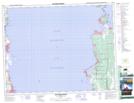
Maps showing Plage Albert, 19,20-7-E, Manitoba
Plage Albert is a Unincorporated area located in 19,20-7-E, Manitoba.
- Latitude: 50° 40' 50'' North (decimal: 50.6805555)
- Longitude: 96° 30' 49'' West (decimal: -96.5136111)
- Topography Feature Category: Unincorporated area
- Geographical Feature: Locality
- Canadian Province/Territory: Manitoba
- Location: 19,20-7-E
- Atlas of Canada Locator Map: Plage Albert
- GPS Coordinate Locator Map: Plage Albert Lat/Long
Plage Albert NTS Map Sheets