Maps showing Battle River, 21-43-16-W3, Saskatchewan
Battle River is a River located in 21-43-16-W3, Saskatchewan and has an elevation of 490 meters.
- Latitude: 52° 43' North (decimal: 52.7167322)
- Longitude: 108° 15' West (decimal: -108.2506816)
- Topography Feature Category: River
- Geographical Feature: River
- Canadian Province/Territory: Saskatchewan
- Elevation: 490 meters
- Location: 21-43-16-W3
- Atlas of Canada Locator Map: Battle River
- GPS Coordinate Locator Map: Battle River Lat/Long
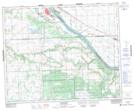
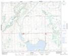
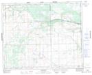
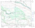
Battle River NTS Map Sheets
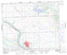
073C09 Battleford Topographic Map at 1:50,000 scale
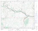
073C13 Marsden Topographic Map at 1:50,000 scale
073C14 Baldwinton Topographic Map at 1:50,000 scale
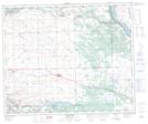
073C15 Delmas Topographic Map at 1:50,000 scale
073C16 North Battleford Topographic Map at 1:50,000 scale
073D16 Mclaughlin Topographic Map at 1:50,000 scale
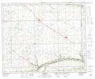
073F03 Maidstone Topographic Map at 1:50,000 scale
073F04 Lashburn Topographic Map at 1:50,000 scale
073C North Battleford Topographic Map at 1:250,000 scale
073D Wainwright Topographic Map at 1:250,000 scale
073F St Walburg Topographic Map at 1:250,000 scale