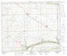
Maps showing Davidson Coulee, 47-25-W3, Saskatchewan
Davidson Coulee is a Valley located in 47-25-W3, Saskatchewan and has an elevation of 565 meters.
- Latitude: 53° 3' North (decimal: 53.0500800)
- Longitude: 109° 31' West (decimal: -109.5174182)
- Topography Feature Category: Valley
- Geographical Feature: Coulee
- Canadian Province/Territory: Saskatchewan
- Elevation: 565 meters
- Location: 47-25-W3
- Atlas of Canada Locator Map: Davidson Coulee
- GPS Coordinate Locator Map: Davidson Coulee Lat/Long
Davidson Coulee NTS Map Sheets