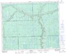
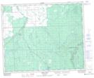
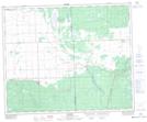
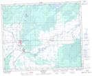
Maps showing Etomami River, 28-44-3-W2, Saskatchewan
Etomami River is a River located in 28-44-3-W2, Saskatchewan and has an elevation of 483 meters.
- Latitude: 52° 49' North (decimal: 52.8166830)
- Longitude: 102° 23' West (decimal: -102.3838074)
- Topography Feature Category: River
- Geographical Feature: River
- Canadian Province/Territory: Saskatchewan
- Elevation: 483 meters
- Location: 28-44-3-W2
- Atlas of Canada Locator Map: Etomami River
- GPS Coordinate Locator Map: Etomami River Lat/Long
Etomami River NTS Map Sheets